.
AURORA BEACH COTTAGE
Walking
see also Freycinet National Park
Douglas - Apsley National Park
Visitors to the Douglas Apsley National Park and users of the Leeabarra Track are advised that:
Vehicle access to the northern entrance to Douglas Apsley National Park (via the E-Road) is 4 WD only.
(Feb. 2019)
Do not walk the Leeabarra Track from south to north, as this
will spread phytopthera into the northern parts of the NP (see below)
For track enquiries, contact the National Parks Office in Coles Bay Tel: (03) 6256 7070
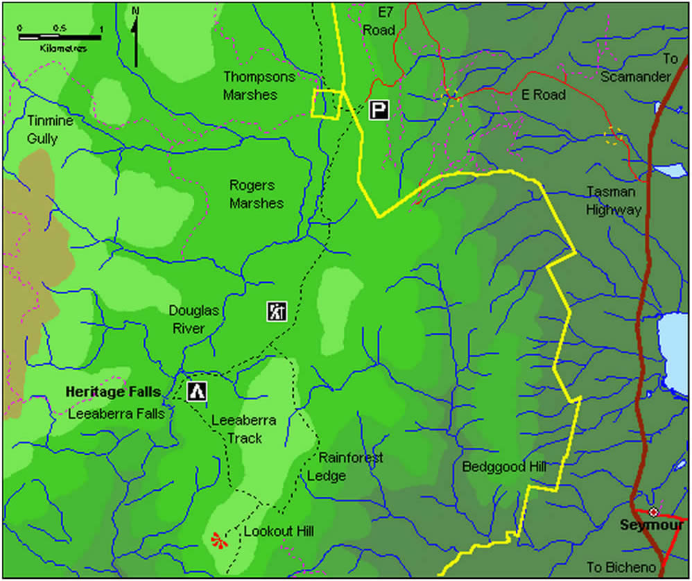
Thompsons Marshes in the north of the park is the starting point for the Leeaberra track. To reach Thompsons Marshes, travel 6 km north from "Aurora Beach Cottage" on the Tasman Highway and turn left (west) after crossing Stonyford Creek onto the 'E road'. The 'E road' is partly privately owned, and its use is at the discretion of the owners, APPM Forest Holdings. Follow the signs for ~ 7 km to Thompsons Marshes carpark. The road becomes steeper and rougher, and a vehicle with high clearance may be needed for the last 2 km. You reach locked gates near the Thompsons Marshes carpark.
.
Help stop the Phytophthora root rot fungus. Keep vehicles on roads. Please keep to the walking tracks and ensure you start your walk with clean boots, gaiters, tent pegs etc so as not to introduce Phytophthora root rot into the northern end of the park.
Douglas-Apsley National Park (source: Tasmanian Government 1993) Douglas-Apsley National Park is a place of rugged and wild beauty. Over aeons, powerful rivers have carved deep gorges into the dolerite-capped plateau of the park. Dramatic waterfalls and tranquil rock pools are picturesque features of these rivers. Forests of eucalypts stand tall on steep slopes and river flats, while pockets of rainforest lay almost hidden in gullies and on protected ledges.
Situated between the townships of Bicheno and St Marys, Douglas-Apsley National Park, named after the two major rivers within its boundaries, protects an area of 16080 ha;
the largest area of undisturbed dry sclerophyll forest remaining in Tasmania.
The park offers the contrast of both dry and wet environments. The south-east corner of the park receives as little as 600 mm of rain each year, while towards the north, rainfall approaches 1 000 mm.
The main rock type in the park is Jurassic dolerite formed about 165 million years ago, which has intruded and in places overlies sediments of sandstone, mudstone and silts tone 200 to 300 million years old. Coal, which is found within these deposits, has been mined in the past. These deposits formed in ancient swamps under tropical or subtropical conditions. The Jurassic dolerite is clearly evident in the columnar jointing along cliff lines. The park's landforms developed primarily as water eroded the dolerite cap, resulting in the deep river valleys and gorges which can be seen today.
The soils in the park are typically rocky and support a wide range of vegetation types. The soils often contain charcoal fragments which are important for understanding fire history in the park. The park has had no major fires in fifty years.
History - Aboriginal heritage
Aborigines of eastern Tasmania were once nomadic gatherer-hunters identified by their association with specific tracts of land. Land was the basis for all Aboriginal social and economic relationships before
people were dispossessed as a result of European invasion.
The area now known as the Douglas-Apsley National Park was close to the Oyster Bay - North East Tribal boundary. The fauna and flora of the Park were important resources to the Leetermairremeller who utilised the area. Apart from food sources, materials in the region could be used to make various tools, containers, ornaments, clothing and weapons.
For Aboriginal people today the land continues to be important, and the sites and landscapes survive as testament to people who lived here in the past and for the generations who will visit in the future.
European history - Coal Mining
The Douglas-Apsley region has a long history of coal mining which began with the establishment of the Douglas River Coal Company in 1849 and continued spasmodically until the 1950' s. Adits or tunnels from mining activities during the 1850's can still be seen in the bed of the Denison Rivulet. The adits below Organ Hill and the old stone remains on the south bank of the Douglas River are the vestiges of coal mining in 1925.
Farming The remains of "Thorne's" farmhouse at Thompsons
Marshes and the outlines of related furrows and drains date to the period between 1870 and 1890. A number of grazing leases were later granted over different parts of the park.
Trapping
The furs of kangaroo, wallaby and possum became valuable after World War I until the end of World War II when fur prices fell and other work became available. Snarers began using the Douglas-Apsley area in 1921, and at the peak of the industry there were about 15 trappers utilising the same camp sites throughout each season. During the summer trappers burnt areas to encourage new growth and attract the animals which were trapped in winter when furs were thickest.
Vegetation A great variety of plant communities can be found in Douglas-Apsley National Park. The park is famous for its dry forests of eucalypts, allocasuarinas and Oyster Bay pines. Fourteen of Tasmania's 26 eucalypt species have been found in the park. One of these, Barbers gum Eucalyptus barberi is protected only in this park. A fine stand of the very rare South Esk pine Callitris oblol1ga is located on the banks of the Apsley River. This plant is unique to Tasmania and is also only protected in the park. The area around the Apsley River contains the habitat of the newly described heath Epacris apsleyensis. The only known native population of the tall srub Polyscias sambucifolius was recently discovered in the park.
The park supports other forest types, such as wet forest and rainforest. Rainforest is found on moist east and south facing slopes or in deep gullies, and can only exist on sites totally free from fire. Many rare plants occur here, particularly in the dry south-east and also on sites where there have been few fires, such as along river edges. In fact, the park protects more than 25 plant species which are not reserved anywhere else. At present little is known about the distribution and composition of the lichens, moss and liverwort flora.
Animals
Mammals known to inhabit the park include: Bennetts wallaby, Tasmanian paden1elon, long-nosed potoroo, Tasmanian devil, eastern quoll, brushtail possum, ringtail possum, little pygmy possum, eastern pygmy possum, wombat, eastern barred bandicoot and Tasmanian bettong. Several species of bats also make /,' their homes here. Over sixty-five different types of birds live in the park. Old forest trees provide nesting hollows for birds such as the black cockatoo, swift parrot, musk lorikeet and green rosella. Birds of prey, such as wedge-tailed eagles and peregrine falcons, also live and breed in the park, as does the nocturnal Australian owlet nightjar. Reptiles found in the park include the blue-tongued lizard, several species of small skinks, the mountain dragon and tiger, copperhead and white-lipped whip snakes. Snakes do not normally pose a problem for park visitors. If you see a snake, leave it alone. If it lies across your intended path, make a noise (from a distance) by stamping your feet to scare it off. But first, make sure you are not blocking its escape route.
The Douglas River is also home for the rare freshwater fish, the Australian grayling. This small silvery fish with an olive back was once common in Tasmanian coastal streams.
Walking Thompsons Marshes in the north of the park is the starting point for the Leeaberra track. To reach Thompsons Marshes, travel 6 km north from "Aurora Beach Cottage" on the Tasman Highway and turn left (west) after crossing Stonyford Creek onto the 'E road'. The 'E road' is partly privately owned, and its use is at the discretion of the owners, APPM Forest Holdings. Follow the signs for ~ 7 km to Thompsons Marshes carpark. A vehicle with high clearance may be required for the last 2 km. Walk from Thompson's Marshes to the first (northern) junction with the rainforest shelf loop track. Continue on above the junction to Heritage Falls campsite (on the northern bank of the Douglas River). Allow 2 ½ hours. For a side trip (45 min return) rockhop downstream to Heritage and Leeaberra Falls where there are great swimming pools. Take care climbing down to these pools.
Heritage Falls: 5 - 6 hours return. Easy Grade. Follow the orange markers to Heritage Falls campsite. From there follow the yellow markers to the top of the spectacular falls.
Heritage Falls - Rainforest Shelf circuit: 7 - 8 hours return (overnight trip recommended). Grade moderate. Carry water over Rainforest Shelf. Follow orange markers to Heritage Falls campsite and camp overnight. Orange markers lead up the steep climb to Lookout Hill track junction. Follow the signs and yellow markers down to the Rainforest Shelf and back onto the Leeaberra track to return to Thompsons Marshes.
Leeaberra Track: 2 1/2 days or 28 km one way to Apsley Waterhole. Moderate to difficult grade. Recommended for experienced walkers only as the route is difficult to follow in some places. Orange triangular markers act as main route markers and yellow triangular markers identify side tracks. This walk must be walked from North to South only to prevent the spread of Phytophthora root rot. Day 1: Walk from Thompson's Marshes to the first (northern) junction with the rainforest shelf loop track. Continue on above the junction to Heritage Falls campsite (on the northern bank of the Douglas River). Allow 2 ½ hours. For a side trip (45 min return) rockhop downstream to Heritage and Leeaberra Falls where there are great swimming pools. Take care climbing down to these pools.
Day 2: Heritage Falls campsite to Lookout Hill (southern junction of rainforest shelf track), 1 1/2 hours. From Lookout Hill take a side track down over the ridge to the rainforest shelf 1 - 2 hours return. This track is relatively well marked with yellow triangles.
From Lookout Hill continue on to Nichols Cap track junction, 45 min. The side track to Nichols Cap offers spectacular views of the park over the Douglas River valley and east coast, 40 min return.
Nichols Cap track junction to Douglas River Crossing, 1 V2 hours. This track is overgrown and scrubby in places and involves a steep descent. Camp on the southern bank of the river.
Water must be carried for day 2 of the walk as none is available between Heritage Falls and the Douglas River.
Day 3: Douglas Crossing to the end of the old exploration road (steepish climb), 2 1/2 hours. Follow the track from the end of the exploration track to the southern crossing of the Denison Rivulet (poorly marked) and on to Mount Andrew saddle. Continue on to the Apsley River Waterhole, 31;2 hours.
Two major threats - Phytophthora root rot - a plant disease
Phytophthora cinnamomi, a plant root rot fungus, was introduced into the park during mineral and/ or forestry exploration work. It is a major problem. Some species of plants die when the fungus attacks their roots. As the roots rot, they cannot take up the water or nutrients they need.
The fungus is transported in soil and water. Vehicles are a big problem as soil containing the fungus is spread by tyres. For this reason old exploration tracks in the park have been closed. The fungus is also spread on boots and other items of equipment which carry mud or dirt.
Phytophthora root rot is present along the Leeaberra track and other vehicle tracks from the Douglas River area to the southern end of the park. To keep the northern area of the park free from disease it is essential that walkers observe the following points:
· Start your walk with clean boots, gaiters, tent pegs etc. . Stay on the marked tracks to prevent infecting adjacent areas.
· If starting your walk from the northern end of the park and walking further south than Nichols Cap do not return to the northern end, continue on to exit the park at the Apsley River trackhead.
· You may do a round trip in the northern end of the park provided your walk does not go south of Nichols Cap.
· If starting from the southern end of the park do not walk north of the Douglas River or you may spread Phytophthora root rot to the uninfected part of the track.
Fire
Fire within the park needs to be very carefully managed to protect habitats, lives and property. The terrain and dense forests of Douglas-Apsley National Park dictate that any wild fires will be extremely difficult to control.
For these reasons Douglas-Apsley National Park is a Fuel Stove Only Area between 1 October and 30 April. During this time open fires are not permitted. Fuel stoves are preferred all year round.
If you must have a campfire (only outside the prohibited period) keep your fire small to conserve wood and reduce campsite degradation. Dead wood is an
important habitat for insects and lizards, while many. birds nest in the hollows in dead limbs.
Use only wood which is both dead and on the ground. Clear the ground around your fire. Make sure your fire is properly extinguished with water before you leave it.
Minimal Impact Bushwalking
Reduce your impact on the environment by following the MIB code:
· Walk 'Softly' - keep to the tracks, this limits damage to surrounding areas.
· How Not To Get 'Gastro' - in areas without toilets bury waste 100 m away from water or campsites. Dig a hole 15 cm deep (using a hand trowel) and bury all faecal waste and toilet paper.
For more details about MIB ask for the following brochures: "Bushwalking Code: Minimal Impact Bushwalking" and "Welcome to the Wilderness"; or contact the Freycinet National Park Office for up-to-date environmental and safety information.
Take Care:
Douglas-Apsley National Park is a special place, providing a refuge for plants and animals, and protecting cultural sites and landforms. Please enjoy your visit and remember that continued protection of this park depends on your support.
Please remember:
| Aboriginal sites, plants, animals and rocks are protected. Please do not damage or remove them. |
| Pets can disturb native animals and are not permitted in national parks. |
| There are no bins, take all your rubbish away. Make sure no soap, food scraps or other pollutants enter streams. Follow minimal impact guidelines for walking and camping. |
| This is a Fuel Stove Only area between 1 October and 30 April. Bring your own portable fuel stove. |
| National parks are protected areas, guns and other hunting equipment are prohibited. |
Help stop the Phytophthora root rot fungus. Keep vehicles on roads. Please keep to the walking tracks and ensure you start your walk with clean boots, gaiters, tent pegs etc so as not to introduce Phytophthora root rot into the northern end of the park.
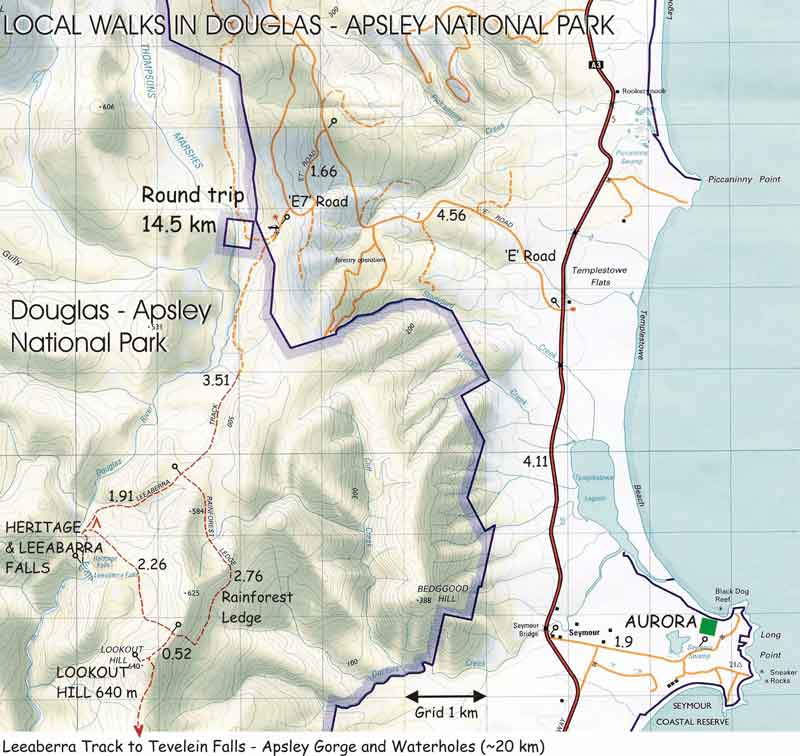
Orange - Access to Walking Tracks Green - National Park Walking Tracks Broken Orange - Emergency use only

Orange - Access to Walking Tracks Green - National Park Walking Tracks Broken Orange - Emergency use only

Enlargments